Thank you for supporting this site ❤️
Make a donation
Make a donation
Gear up for your next adventure:
As an Amazon Associate, this site earns from qualifying purchases at no extra cost to you.
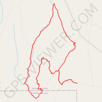
Loop bike in Wenas Wildlife Area
- Distance: 6.4 mi
- Elevation gain: 190 m
- Maximum elevation: 942 m
- Elevation loss: 187 m
- Minimum elevation: 822 m
- Moving time: 1 h 6 m
- Moving speed: 5.8 mph
- Maximum speed: 18.1 mph
- Total time: 2 h 4 m
- Global speed: 3.1 mph
Interactive trail map
Thank you for supporting this site ❤️
Make a donation
Make a donation
Gear up for your next adventure:
As an Amazon Associate, this site earns from qualifying purchases at no extra cost to you.
Trail profile
- Distance: 6.4 mi
- Elevation gain: 190 m
- Maximum elevation: 942 m
- Elevation loss: 187 m
- Minimum elevation: 822 m
- Moving time: 1 h 6 m
- Moving speed: 5.8 mph
- Maximum speed: 18.1 mph
- Total time: 2 h 4 m
- Global speed: 3.1 mph
Thank you for supporting this site ❤️
Make a donation
Make a donation
Gear up for your next adventure:
As an Amazon Associate, this site earns from qualifying purchases at no extra cost to you.
About this trail
Name: Loop bike in Wenas Wildlife Area trail, distance, elevation, map, profile, GPS track
Start: 13879, Umtanum Road, Kittitas County, Washington, 98926, United States (46.91406 -120.63625)
End: 13754, Umtanum Road, Kittitas County, Washington, 98926, United States (46.91392 -120.63470)
Coordinates: 46.91008 -120.65444 46.93421 -120.63470
Thank you for supporting this site ❤️
Make a donation
Make a donation
Gear up for your next adventure:
As an Amazon Associate, this site earns from qualifying purchases at no extra cost to you.