Coventry Running
- Distance: 16.5 mi
- Elevation gain: 144 m
- Maximum elevation: 94 m
- Elevation loss: 145 m
- Minimum elevation: 69 m
- Moving time: 2 h 26 m
- Moving speed: 6.8 mph
- Maximum speed: 11.6 mph
- Total time: 2 h 38 m
- Global speed: 6.3 mph
Interactive trail map
Trail profile
- Distance: 16.5 mi
- Elevation gain: 144 m
- Maximum elevation: 94 m
- Elevation loss: 145 m
- Minimum elevation: 69 m
- Moving time: 2 h 26 m
- Moving speed: 6.8 mph
- Maximum speed: 11.6 mph
- Total time: 2 h 38 m
- Global speed: 6.3 mph
About this trail
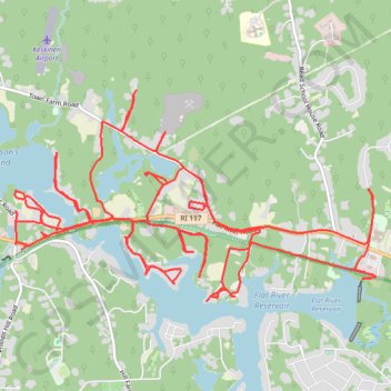
Name: Coventry Running trail, distance, elevation, map, profile, GPS track
Start: Brenda Drive, Coventry, Kent County, Rhode Island, 02816, United States (41.70149 -71.59337)
End: Brenda Drive, Coventry, Kent County, Rhode Island, 02816, United States (41.70157 -71.59324)
Coordinates: 41.69714 -71.63519 41.71596 -71.59206