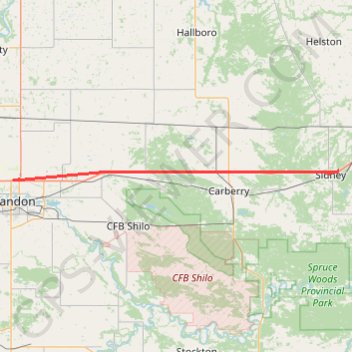
Import a GPX file

Brandon - Sidney

#Bike #Brandon #Sidney

  • Distance: 41.2 mi
  • Elevation gain: 104 m
  • Maximum elevation: 407 m
  • Elevation loss: 133 m
  • Minimum elevation: 376 m

Interactive trail map

Trail profile

  • Distance: 41.2 mi
  • Elevation gain: 104 m
  • Maximum elevation: 407 m
  • Elevation loss: 133 m
  • Minimum elevation: 376 m

About this trail

Name: Brandon - Sidney trail, distance, elevation, map, profile, GPS track

Start: Meadowlark Campground, Deer Ridge Road, Brandon, Rural Municipality of Elton, Manitoba, R7C 1A7, Canada (49.88747 -99.95569)

End: Sidney, Municipality of North Norfolk, Manitoba, Canada (49.90255 -99.05858)

Coordinates: 49.88680 -99.95570 49.90255 -99.05858

Other hiking, mountain biking, running and outdoor activity trails

Click on a trail to view its statistics, map and profile.

Sidney - Portage la Prairie

Canada > Municipality of North Norfolk > Sidney

#Bike #Sidney #PortageLaPrairie

Distance: 36.7 mi • Elevation gain: 39 m • Maximum elevation: 379 m

Virden - Brandon

Canada > Virden

#Bike #Virden #Brandon

Distance: 49.5 mi • Elevation gain: 137 m • Maximum elevation: 446 m

Gear up for your next adventure:

🔥Reusable Hand Warmers - Maintain dexterity in your fingers for precise map handling
🚲Bikepacking Frame Bags - Storage for tools and navigation gear on long off-road rides
🥾Walking Shoes - Lightweight walking shoes for countryside and coastal paths
🧢Hiking Hats - Sun and weather protection for outdoor walks
👟Heavy Duty Boot Laces - Always carry a spare for your hiking footwear

As an Amazon Associate, this site earns from qualifying purchases at no extra cost to you.