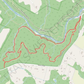
Gunpowder Falls State Park Pleasantville Area - Little Gunpowder Trail and A Boy Named Sue loop
- Distance: 2.9 mi
- Elevation gain: 99 m
- Maximum elevation: 146 m
- Elevation loss: 99 m
- Minimum elevation: 96 m
- Moving time: 1 h 11 m
- Moving speed: 2.4 mph
- Maximum speed: 7.6 mph
- Total time: 1 h 40 m
- Global speed: 1.7 mph
Interactive trail map
Trail profile
- Distance: 2.9 mi
- Elevation gain: 99 m
- Maximum elevation: 146 m
- Elevation loss: 99 m
- Minimum elevation: 96 m
- Moving time: 1 h 11 m
- Moving speed: 2.4 mph
- Maximum speed: 7.6 mph
- Total time: 1 h 40 m
- Global speed: 1.7 mph
About this trail
Name: Gunpowder Falls State Park Pleasantville Area - Little Gunpowder Trail and A Boy Named Sue loop trail, distance, elevation, map, profile, GPS track
Start: 13971, Bottom Road, Baltimore County, Maryland, 21082, United States (39.50524 -76.43317)
End: 13969, Bottom Road, Baltimore County, Maryland, 21082, United States (39.50520 -76.43328)
Coordinates: 39.49864 -76.44613 39.50524 -76.43317
Other hiking, mountain biking, running and outdoor activity trails
Click on a trail to view its statistics, map and profile.
Gunpowder Falls State Park Pleasantville Area - Little Gunpowder Trail
United States > Maryland > Harford County
Distance: 5.5 mi • Elevation gain: 147 m • Maximum elevation: 104 m