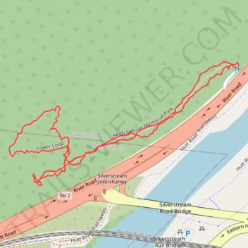
Keith George Memorial Park Lower Loop
- Distance: 1.0 mi
- Elevation gain: 67 m
- Maximum elevation: 109 m
- Elevation loss: 66 m
- Minimum elevation: 49 m
- Moving time: 34 m 49 s
- Moving speed: 1.7 mph
- Maximum speed: 4.7 mph
- Total time: 35 m 58 s
- Global speed: 1.7 mph
Interactive trail map
Trail profile
- Distance: 1.0 mi
- Elevation gain: 67 m
- Maximum elevation: 109 m
- Elevation loss: 66 m
- Minimum elevation: 49 m
- Moving time: 34 m 49 s
- Moving speed: 1.7 mph
- Maximum speed: 4.7 mph
- Total time: 35 m 58 s
- Global speed: 1.7 mph
About this trail
Name: Keith George Memorial Park Lower Loop trail, distance, elevation, map, profile, GPS track
Coordinates: -41.14494 174.99400 -41.14275 174.99939