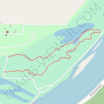
Sherwood's Loop Trail - Seminole Valley Park
- Distance: 0.9 mi
- Elevation gain: 18 m
- Maximum elevation: 231 m
- Elevation loss: 18 m
- Minimum elevation: 222 m
- Moving time: 15 m 37 s
- Moving speed: 3.4 mph
- Maximum speed: 7.2 mph
- Total time: 15 m 37 s
- Global speed: 3.4 mph
Interactive trail map
Trail profile
- Distance: 0.9 mi
- Elevation gain: 18 m
- Maximum elevation: 231 m
- Elevation loss: 18 m
- Minimum elevation: 222 m
- Moving time: 15 m 37 s
- Moving speed: 3.4 mph
- Maximum speed: 7.2 mph
- Total time: 15 m 37 s
- Global speed: 3.4 mph
About this trail
Name: Sherwood's Loop Trail - Seminole Valley Park trail, distance, elevation, map, profile, GPS track
Start: Sherwood's, Cedar Rapids, Linn County, Iowa, 52405, United States (42.00210 -91.72738)
End: Sherwood's, Cedar Rapids, Linn County, Iowa, 52405, United States (42.00131 -91.72768)
Coordinates: 42.00113 -91.72768 42.00360 -91.72075