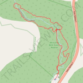
White Pine Bush Scenic Reserve Loop Track
- Distance: 1.2 mi
- Elevation gain: 42 m
- Maximum elevation: 265 m
- Elevation loss: 45 m
- Minimum elevation: 219 m
- Moving time: 45 m 14 s
- Moving speed: 1.5 mph
- Maximum speed: 2.8 mph
- Total time: 1 h 7 m
- Global speed: 1.0 mph
Interactive trail map
Trail profile
- Distance: 1.2 mi
- Elevation gain: 42 m
- Maximum elevation: 265 m
- Elevation loss: 45 m
- Minimum elevation: 219 m
- Moving time: 45 m 14 s
- Moving speed: 1.5 mph
- Maximum speed: 2.8 mph
- Total time: 1 h 7 m
- Global speed: 1.0 mph
About this trail
Name: White Pine Bush Scenic Reserve Loop Track trail, distance, elevation, map, profile, GPS track
Start: White Pine Bush track (paved), Hastings District, Hawke's Bay, New Zealand (-39.28934 176.87964)
End: White Pine Bush track (paved), Hastings District, Hawke's Bay, New Zealand (-39.28964 176.87947)
Coordinates: -39.28968 176.87623 -39.28494 176.88065