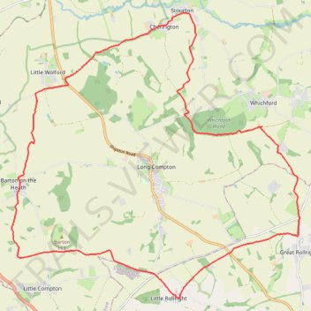
Cherington ➡️ Rollright ➡️ Wolford ➡️ Cherington
- Distance: 15.4 mi
- Elevation gain: 419 m
- Maximum elevation: 244 m
- Elevation loss: 419 m
- Minimum elevation: 89 m
- Moving time: 2 h 42 m
- Moving speed: 5.7 mph
- Maximum speed: 9.4 mph
- Total time: 2 h 44 m
- Global speed: 5.6 mph
Interactive trail map
Trail profile
- Distance: 15.4 mi
- Elevation gain: 419 m
- Maximum elevation: 244 m
- Elevation loss: 419 m
- Minimum elevation: 89 m
- Moving time: 2 h 42 m
- Moving speed: 5.7 mph
- Maximum speed: 9.4 mph
- Total time: 2 h 44 m
- Global speed: 5.6 mph
About this trail
Name: Cherington ➡️ Rollright ➡️ Wolford ➡️ Cherington trail, distance, elevation, map, profile, GPS track
Start: Cherington, Stratford-on-Avon, Warwickshire, England, CV36 5HL, United Kingdom (52.02534 -1.57966)
End: Cherington, Stratford-on-Avon, Warwickshire, England, CV36 5HL, United Kingdom (52.02540 -1.57943)
Coordinates: 51.96795 -1.62985 52.02822 -1.53124
Topography: Stratford-on-Avon topographic map, elevation, terrain