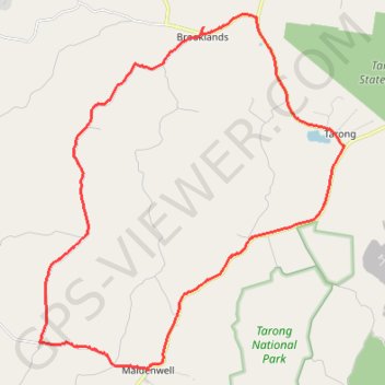
Brooklands to Maidenwell
Brooklands, Maidenwell, Tarong, Queensland
- Distance: 24.0 mi
- Elevation gain: 461 m
- Maximum elevation: 544 m
- Elevation loss: 461 m
- Minimum elevation: 373 m
Interactive trail map
Trail profile
- Distance: 24.0 mi
- Elevation gain: 461 m
- Maximum elevation: 544 m
- Elevation loss: 461 m
- Minimum elevation: 373 m
About this trail
Name: Brooklands to Maidenwell trail, distance, elevation, map, profile, GPS track
Coordinates: -26.84727 151.76141 -26.73564 151.86866
Other hiking, mountain biking, running and outdoor activity trails
Click on a trail to view its statistics, map and profile.
Goodger to Ellesmere and Archookoora State Forest
Goodger, Brooklands, Ellesmere, Haly Creek, Archookoora, Queensland
Distance: 29.7 mi • Elevation gain: 622 m • Maximum elevation: 551 m
Goodger to Ellesmere
Goodger, Brooklands, Ellesmere, Haly Creek, Archookoora, Queensland
Distance: 26.6 mi • Elevation gain: 375 m • Maximum elevation: 615 m
Oaky Creek Back Road
Distance: 15.3 mi • Elevation gain: 296 m • Maximum elevation: 582 m