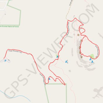
Yonah Mountain Loop
Interactive trail map
Trail profile
- Distance: 4.2 mi
- Elevation gain: 471 m
- Maximum elevation: 952 m
- Elevation loss: 471 m
- Minimum elevation: 530 m
About this trail
Name: Yonah Mountain Loop trail, distance, elevation, map, profile, GPS track
Start: Yonah Mountain Trail, White County, Georgia, United States (34.63740 -83.72565)
End: Yonah Mountain Trail, White County, Georgia, United States (34.63740 -83.72564)
Coordinates: 34.63434 -83.72565 34.64207 -83.71230
Other hiking, mountain biking, running and outdoor activity trails
Click on a trail to view its statistics, map and profile.
Mount Yonah Trail in Chattahoochee-Oconee National Forest
United States > Georgia > White County
The Mount Yonah Trail presents a rewarding hike for those prepared for a challenge. As you ascend through lush forests of hardwoods and pines, you’ll encounter rocky outcroppings and steep sections, with the ultimate payoff being breathtaking panoramic views from the summit. From here, hikers can enjoy…
Distance: 4.5 mi • Elevation gain: 477 m • Maximum elevation: 951 m