Thank you for supporting this site ❤️
Make a donation
Make a donation
Gear up for your next adventure:
As an Amazon Associate, this site earns from qualifying purchases at no extra cost to you.
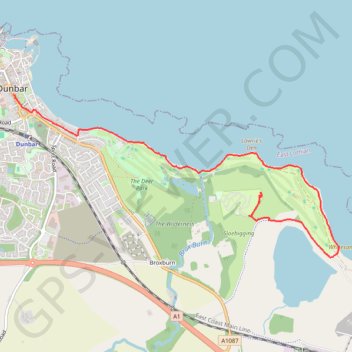
Dunbar Camping & Caravanning site to Tyninghame
- Distance: 3.4 mi
- Elevation gain: 38 m
- Maximum elevation: 24 m
- Elevation loss: 35 m
- Minimum elevation: 0 m
- Moving time: 1 h 22 m
- Moving speed: 2.5 mph
- Maximum speed: 3.6 mph
- Total time: 1 h 37 m
- Global speed: 2.1 mph
Interactive trail map
Thank you for supporting this site ❤️
Make a donation
Make a donation
Gear up for your next adventure:
As an Amazon Associate, this site earns from qualifying purchases at no extra cost to you.
Trail profile
- Distance: 3.4 mi
- Elevation gain: 38 m
- Maximum elevation: 24 m
- Elevation loss: 35 m
- Minimum elevation: 0 m
- Moving time: 1 h 22 m
- Moving speed: 2.5 mph
- Maximum speed: 3.6 mph
- Total time: 1 h 37 m
- Global speed: 2.1 mph
Thank you for supporting this site ❤️
Make a donation
Make a donation
Gear up for your next adventure:
As an Amazon Associate, this site earns from qualifying purchases at no extra cost to you.
About this trail
Name: Dunbar Camping & Caravanning site to Tyninghame trail, distance, elevation, map, profile, GPS track
End: High Street, Belhaven, Dunbar, East Lothian, Scotland, EH42 1EW, United Kingdom (56.00159 -2.51565)
Coordinates: 55.98829 -2.51565 56.00159 -2.46813
Topography: East Lothian topographic map, elevation, terrain
Thank you for supporting this site ❤️
Make a donation
Make a donation
Gear up for your next adventure:
As an Amazon Associate, this site earns from qualifying purchases at no extra cost to you.