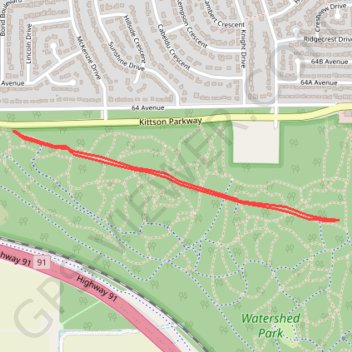
Import a GPX file

Watershed Park

#Hiking #Bike

  • Distance: 1.6 mi
  • Elevation gain: 39 m
  • Maximum elevation: 83 m
  • Elevation loss: 39 m
  • Minimum elevation: 43 m

Interactive trail map

Trail profile

  • Distance: 1.6 mi
  • Elevation gain: 39 m
  • Maximum elevation: 83 m
  • Elevation loss: 39 m
  • Minimum elevation: 43 m

About this trail

Other hiking, mountain biking, running and outdoor activity trails

Click on a trail to view its statistics, map and profile.

Vancouver - Golden

Canada > British Columbia > Metro Vancouver Regional District > Vancouver

#Bike #Vancouver #Golden

Distance: 514.2 mi • Elevation gain: 9,376 m • Maximum elevation: 1,347 m

Gear up for your next adventure:

🧼Technical Clothing Wash - Special soap to clean and restore waterproof membranes
🧥Breathable Waterproof Jackets - Essential rain protection for the unpredictable British climate
🎒Backpack Rain Covers - Universal waterproof covers to protect your gear from downpours
Lightweight Solo Tents - Backpacking tents designed for wild camping in the UK highlands
🗺️Topographic Maps - Detailed maps showing elevation and terrain features

As an Amazon Associate, this site earns from qualifying purchases at no extra cost to you.