Make a donation
Gear up for your next adventure:
As an Amazon Associate, this site earns from qualifying purchases at no extra cost to you.
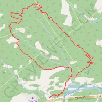
Elbow, Sugar Daddy, Strange Brew, Bobcat and Fullerton Loop
Kananaskis Country Public Land Use Zone. Elbow River. #Hiking #Running #Loop #Kananaskis
- Distance: 7.5 mi
- Elevation gain: 376 m
- Maximum elevation: 1,714 m
- Elevation loss: 376 m
- Minimum elevation: 1,393 m
Interactive trail map
Make a donation
Gear up for your next adventure:
As an Amazon Associate, this site earns from qualifying purchases at no extra cost to you.
Trail profile
- Distance: 7.5 mi
- Elevation gain: 376 m
- Maximum elevation: 1,714 m
- Elevation loss: 376 m
- Minimum elevation: 1,393 m
Make a donation
Gear up for your next adventure:
As an Amazon Associate, this site earns from qualifying purchases at no extra cost to you.
About this trail
Name: Elbow, Sugar Daddy, Strange Brew, Bobcat and Fullerton Loop trail, distance, elevation, map, profile, GPS track
Coordinates: 50.90223 -114.70685 50.92686 -114.67177
Make a donation
Gear up for your next adventure:
As an Amazon Associate, this site earns from qualifying purchases at no extra cost to you.
Other hiking, mountain biking, running and outdoor activity trails
Click on a trail to view its statistics, map and profile.
Sugar Pony MTB trail
Canada > Alberta > Kananaskis Improvement District
Distance: 0.6 mi • Elevation gain: 39 m • Maximum elevation: 1,659 m