Make a donation
Gear up for your next adventure:
As an Amazon Associate, this site earns from qualifying purchases at no extra cost to you.
עין הוד
Morning Ride
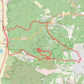
- Distance: 17.8 mi
- Elevation gain: 790 m
- Maximum elevation: 487 m
- Elevation loss: 790 m
- Minimum elevation: 24 m
- Moving time: 3 h 13 m
- Moving speed: 5.5 mph
- Maximum speed: 28.0 mph
- Total time: 4 h 47 m
- Global speed: 3.7 mph
Interactive trail map
Make a donation
Gear up for your next adventure:
As an Amazon Associate, this site earns from qualifying purchases at no extra cost to you.
Trail profile
- Distance: 17.8 mi
- Elevation gain: 790 m
- Maximum elevation: 487 m
- Elevation loss: 790 m
- Minimum elevation: 24 m
- Moving time: 3 h 13 m
- Moving speed: 5.5 mph
- Maximum speed: 28.0 mph
- Total time: 4 h 47 m
- Global speed: 3.7 mph
Make a donation
Gear up for your next adventure:
As an Amazon Associate, this site earns from qualifying purchases at no extra cost to you.
About this trail
Name: עין הוד trail, distance, elevation, map, profile, GPS track
Coordinates: 32.69483 34.96637 32.72895 35.04240
Make a donation
Gear up for your next adventure:
As an Amazon Associate, this site earns from qualifying purchases at no extra cost to you.
Other hiking, mountain biking, running and outdoor activity trails
Click on a trail to view its statistics, map and profile.
Single Nahal Bustan
Israel > Haifa District > Hof HaCarmel Regional Council
נחל בוסטן - רון
Distance: 18.1 mi • Elevation gain: 625 m • Maximum elevation: 488 m
Home78Rec
Israel > Haifa District > Nesher
Distance: 48.7 mi • Elevation gain: 1,479 m • Maximum elevation: 461 m