Thank you for supporting this site ❤️
Make a donation
Make a donation
Gear up for your next adventure:
As an Amazon Associate, this site earns from qualifying purchases at no extra cost to you.
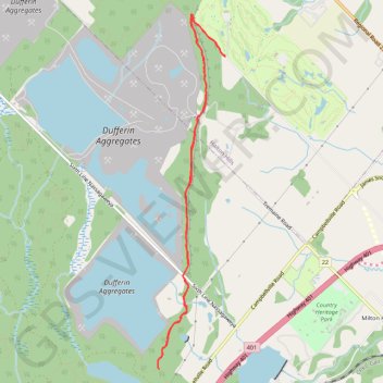
Dufferin Quarry Bridge - Bruce Trail
- Distance: 6.4 mi
- Elevation gain: 204 m
- Maximum elevation: 328 m
- Elevation loss: 204 m
- Minimum elevation: 253 m
Interactive trail map
Thank you for supporting this site ❤️
Make a donation
Make a donation
Gear up for your next adventure:
As an Amazon Associate, this site earns from qualifying purchases at no extra cost to you.
Trail profile
- Distance: 6.4 mi
- Elevation gain: 204 m
- Maximum elevation: 328 m
- Elevation loss: 204 m
- Minimum elevation: 253 m
Thank you for supporting this site ❤️
Make a donation
Make a donation
Gear up for your next adventure:
As an Amazon Associate, this site earns from qualifying purchases at no extra cost to you.
About this trail
Name: Dufferin Quarry Bridge - Bruce Trail trail, distance, elevation, map, profile, GPS track
Coordinates: 43.51163 -79.96049 43.54862 -79.95073
Thank you for supporting this site ❤️
Make a donation
Make a donation
Gear up for your next adventure:
As an Amazon Associate, this site earns from qualifying purchases at no extra cost to you.
Other hiking, mountain biking, running and outdoor activity trails
Click on a trail to view its statistics, map and profile.
Rattlesnake Trail
Canada > Ontario > Halton Region
Distance: 10.8 mi • Elevation gain: 208 m • Maximum elevation: 343 m
Ontario country roads
Distance: 93.4 mi • Elevation gain: 1,137 m • Maximum elevation: 497 m