Peek-a-Boo Slot Canyon, Spooky Slot Canyon and Dry Fork Narrows Loop
Loop hike via Lower Dry Fork Trail, Peek-a-Boo Slot Canyon, Spooky Slot Canyon, Dry Fork Coyote Gulch Trail and Dry Fork Narrows Trail in the Scorpion Wilderness Study Area and the Grand Staircase-Escalante National Monument. #Hiking #Loop #Canyon #Nature #Wilderness
- Distance: 3.7 mi
- Elevation gain: 167 m
- Maximum elevation: 1,512 m
- Elevation loss: 167 m
- Minimum elevation: 1,423 m
- Moving time: 35 m 29 s
- Moving speed: 6.2 mph
- Maximum speed: 7.4 mph
- Total time: 35 m 29 s
- Global speed: 6.2 mph
Interactive trail map
Trail profile
- Distance: 3.7 mi
- Elevation gain: 167 m
- Maximum elevation: 1,512 m
- Elevation loss: 167 m
- Minimum elevation: 1,423 m
- Moving time: 35 m 29 s
- Moving speed: 6.2 mph
- Maximum speed: 7.4 mph
- Total time: 35 m 29 s
- Global speed: 6.2 mph
About this trail
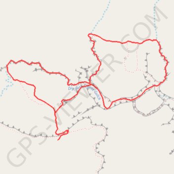
Name: Peek-a-Boo Slot Canyon, Spooky Slot Canyon and Dry Fork Narrows Loop trail, distance, elevation, map, profile, GPS track
Start: Lower Dry Fork Trail, Kane County, Utah, United States (37.47677 -111.22008)
End: Lower Dry Fork Trail, Kane County, Utah, United States (37.47677 -111.22006)
Coordinates: 37.47677 -111.22555 37.48576 -111.20837
Other hiking, mountain biking, running and outdoor activity trails
Click on a trail to view its statistics, map and profile.
Dry Fork Narrows, Peek-A-Boo and Spooky Slot Canyons Loop
United States > Utah > Kane County
From the Dry Fork trailhead near Hole-in-the-Rock Road, the route crosses open slickrock and sandy desert benches before dropping into Dry Fork of Coyote Gulch, where the broad wash leads toward the smooth, shadowed corridors of Dry Fork Narrows. This Scorpion Wilderness Study Area hike sits within Grand…
Distance: 6.1 mi • Elevation gain: 222 m • Maximum elevation: 1,517 m
Spooky Slot Canyon and Peek-A-Boo Slot Canyon Loop Trail
United States > Utah > Kane County
The Peek-A-Boo and Spooky Slot Canyons Loop Trail offers a fascinating, though physically challenging, hiking experience in the Grand Staircase-Escalante National Monument. Hikers are treated to dramatic, narrow passages through the slot canyons, with Peek-A-Boo presenting impressive rock formations and a…
Distance: 2.9 mi • Elevation gain: 156 m • Maximum elevation: 1,512 m