Turpin's Trail West
- Distance: 3.2 mi
- Elevation gain: 55 m
- Maximum elevation: 26 m
- Elevation loss: 58 m
- Minimum elevation: 0 m
- Moving time: 1 h 43 m
- Moving speed: 1.9 mph
- Maximum speed: 6.6 mph
- Total time: 1 h 47 m
- Global speed: 1.8 mph
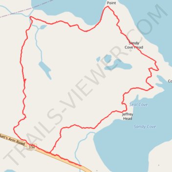
Interactive trail map
Trail profile
- Distance: 3.2 mi
- Elevation gain: 55 m
- Maximum elevation: 26 m
- Elevation loss: 58 m
- Minimum elevation: 0 m
- Moving time: 1 h 43 m
- Moving speed: 1.9 mph
- Maximum speed: 6.6 mph
- Total time: 1 h 47 m
- Global speed: 1.8 mph
About this trail
Name: Turpin's Trail West trail, distance, elevation, map, profile, GPS track
Start: Joe Batt's Arm Road, Tilting, Newfoundland, Newfoundland and Labrador, Canada (49.70949 -54.08815)
End: Joe Batt's Arm Road, Tilting, Newfoundland, Newfoundland and Labrador, Canada (49.70849 -54.08440)
Coordinates: 49.70848 -54.09235 49.72058 -54.07533