Thank you for supporting this site ❤️
Make a donation
Make a donation
Gear up for your next adventure:
As an Amazon Associate, this site earns from qualifying purchases at no extra cost to you.
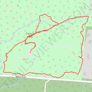
Southeast French Park Loop Walk
- Distance: 2.6 mi
- Elevation gain: 86 m
- Maximum elevation: 260 m
- Elevation loss: 84 m
- Minimum elevation: 206 m
- Moving time: 1 h 25 m
- Moving speed: 1.8 mph
- Maximum speed: 3.4 mph
- Total time: 2 h 52 m
- Global speed: 0.9 mph
Interactive trail map
Thank you for supporting this site ❤️
Make a donation
Make a donation
Gear up for your next adventure:
As an Amazon Associate, this site earns from qualifying purchases at no extra cost to you.
Trail profile
- Distance: 2.6 mi
- Elevation gain: 86 m
- Maximum elevation: 260 m
- Elevation loss: 84 m
- Minimum elevation: 206 m
- Moving time: 1 h 25 m
- Moving speed: 1.8 mph
- Maximum speed: 3.4 mph
- Total time: 2 h 52 m
- Global speed: 0.9 mph
Thank you for supporting this site ❤️
Make a donation
Make a donation
Gear up for your next adventure:
As an Amazon Associate, this site earns from qualifying purchases at no extra cost to you.
About this trail
Name: Southeast French Park Loop Walk trail, distance, elevation, map, profile, GPS track
Coordinates: 39.19537 -84.42786 39.20095 -84.41823
Thank you for supporting this site ❤️
Make a donation
Make a donation
Gear up for your next adventure:
As an Amazon Associate, this site earns from qualifying purchases at no extra cost to you.