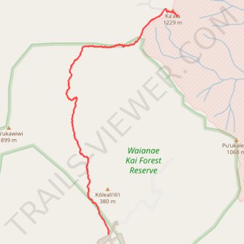
Mount Ka’ala Summit Trail path from parking lot to summit.
- Distance: 3.7 mi
- Elevation gain: 17 m
- Maximum elevation: 1,227 m
- Elevation loss: 1,058 m
- Minimum elevation: 176 m
- Moving time: 1 h 47 m
- Moving speed: 2.0 mph
- Maximum speed: 19.6 mph
- Total time: 2 h 15 m
- Global speed: 1.6 mph
Interactive trail map
Trail profile
- Distance: 3.7 mi
- Elevation gain: 17 m
- Maximum elevation: 1,227 m
- Elevation loss: 1,058 m
- Minimum elevation: 176 m
- Moving time: 1 h 47 m
- Moving speed: 2.0 mph
- Maximum speed: 19.6 mph
- Total time: 2 h 15 m
- Global speed: 1.6 mph
About this trail
Name: Mount Ka’ala Summit Trail path from parking lot to summit. trail, distance, elevation, map, profile, GPS track
Start: Mount Kaala Road, Honolulu County, Hawaii, United States (21.50678 -158.14159)
End: Honolulu County, Hawaii, 96792, United States (21.47524 -158.15218)
Coordinates: 21.47524 -158.15881 21.50787 -158.14149