Mynydd y Glyn, Mynydd Dinas and Mynydd y Cymer Loop Hike
- Distance: 6.9 mi
- Elevation gain: 400 m
- Maximum elevation: 377 m
- Elevation loss: 400 m
- Minimum elevation: 91 m
- Moving time: 3 h 2 m
- Moving speed: 2.3 mph
- Maximum speed: 10.1 mph
- Total time: 3 h 22 m
- Global speed: 2.0 mph
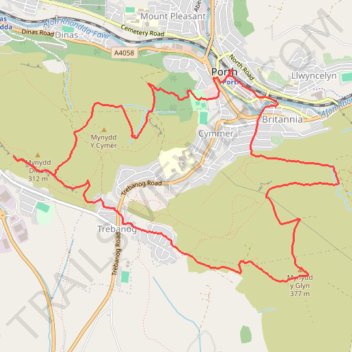
Interactive trail map
Trail profile
- Distance: 6.9 mi
- Elevation gain: 400 m
- Maximum elevation: 377 m
- Elevation loss: 400 m
- Minimum elevation: 91 m
- Moving time: 3 h 2 m
- Moving speed: 2.3 mph
- Maximum speed: 10.1 mph
- Total time: 3 h 22 m
- Global speed: 2.0 mph
About this trail
Name: Mynydd y Glyn, Mynydd Dinas and Mynydd y Cymer Loop Hike trail, distance, elevation, map, profile, GPS track
End: Syphon Street, Porth, Rhondda Cynon Taf, Wales, CF39 9SR, United Kingdom (51.61258 -3.40758)
Coordinates: 51.59621 -3.43505 51.61272 -3.39417
Topography: Rhondda Cynon Taf topographic map, elevation, terrain
Other hiking, mountain biking, running and outdoor activity trails
Click on a trail to view its statistics, map and profile.
The Headstock 500
United Kingdom > Wales > Newport > Newport
Distance: 300.4 mi • Elevation gain: 9,616 m • Maximum elevation: 691 m
Treorchy, Cearphilly, Pen y Fan
United Kingdom > Wales > Caerphilly County Borough > Tredegar
Distance: 79.1 mi • Elevation gain: 1,934 m • Maximum elevation: 501 m