Thank you for supporting this site ❤️
Make a donation
Make a donation
Gear up for your next adventure:
As an Amazon Associate, this site earns from qualifying purchases at no extra cost to you.
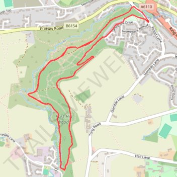
YVAA Pudsey 2025
- Distance: 5.1 mi
- Elevation gain: 184 m
- Maximum elevation: 121 m
- Elevation loss: 187 m
- Minimum elevation: 64 m
Interactive trail map
Thank you for supporting this site ❤️
Make a donation
Make a donation
Gear up for your next adventure:
As an Amazon Associate, this site earns from qualifying purchases at no extra cost to you.
Trail profile
- Distance: 5.1 mi
- Elevation gain: 184 m
- Maximum elevation: 121 m
- Elevation loss: 187 m
- Minimum elevation: 64 m
Thank you for supporting this site ❤️
Make a donation
Make a donation
Gear up for your next adventure:
As an Amazon Associate, this site earns from qualifying purchases at no extra cost to you.
About this trail
Name: YVAA Pudsey 2025 trail, distance, elevation, map, profile, GPS track
Coordinates: 53.78736 -1.64119 53.79807 -1.62783
Topography: Leeds topographic map, elevation, terrain
Thank you for supporting this site ❤️
Make a donation
Make a donation
Gear up for your next adventure:
As an Amazon Associate, this site earns from qualifying purchases at no extra cost to you.