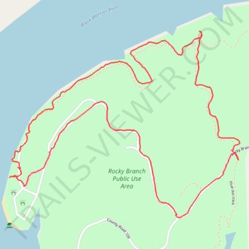
Rocky Branch north loop trail and picnic area
- Distance: 2.9 mi
- Elevation gain: 111 m
- Maximum elevation: 134 m
- Elevation loss: 111 m
- Minimum elevation: 62 m
- Moving time: 1 h 38 m
- Moving speed: 1.8 mph
- Maximum speed: 3.7 mph
- Total time: 2 h 5 m
- Global speed: 1.4 mph
Interactive trail map
Trail profile
- Distance: 2.9 mi
- Elevation gain: 111 m
- Maximum elevation: 134 m
- Elevation loss: 111 m
- Minimum elevation: 62 m
- Moving time: 1 h 38 m
- Moving speed: 1.8 mph
- Maximum speed: 3.7 mph
- Total time: 2 h 5 m
- Global speed: 1.4 mph
About this trail
Name: Rocky Branch north loop trail and picnic area trail, distance, elevation, map, profile, GPS track
Start: Rocky Branch Road, Tuscaloosa County, Alabama, 35444, United States (33.27604 -87.40976)
End: Rocky Branch Road, Tuscaloosa County, Alabama, 35444, United States (33.27604 -87.40973)
Coordinates: 33.27320 -87.42120 33.28119 -87.40939