Make a donation
Gear up for your next adventure:
As an Amazon Associate, this site earns from qualifying purchases at no extra cost to you.
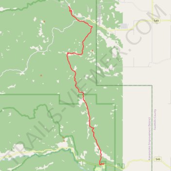
Mesa Butte to Sandy McNabb
- Distance: 12.5 mi
- Elevation gain: 409 m
- Maximum elevation: 1,532 m
- Elevation loss: 357 m
- Minimum elevation: 1,354 m
- Moving time: 4 h 18 m
- Moving speed: 2.9 mph
- Maximum speed: 5.1 mph
- Total time: 4 h 52 m
- Global speed: 2.6 mph
Interactive trail map
Make a donation
Gear up for your next adventure:
As an Amazon Associate, this site earns from qualifying purchases at no extra cost to you.
Trail profile
- Distance: 12.5 mi
- Elevation gain: 409 m
- Maximum elevation: 1,532 m
- Elevation loss: 357 m
- Minimum elevation: 1,354 m
- Moving time: 4 h 18 m
- Moving speed: 2.9 mph
- Maximum speed: 5.1 mph
- Total time: 4 h 52 m
- Global speed: 2.6 mph
Make a donation
Gear up for your next adventure:
As an Amazon Associate, this site earns from qualifying purchases at no extra cost to you.
About this trail
Name: Mesa Butte to Sandy McNabb trail, distance, elevation, map, profile, GPS track
Start: 21105, McLean Creek Trail, Kananaskis Improvement District, Alberta, Canada (50.76496 -114.56708)
End: Long Prairie Link, Kananaskis Improvement District, Alberta, Canada (50.64160 -114.52325)
Coordinates: 50.64037 -114.56927 50.76510 -114.52313
Make a donation
Gear up for your next adventure:
As an Amazon Associate, this site earns from qualifying purchases at no extra cost to you.
Other hiking, mountain biking, running and outdoor activity trails
Click on a trail to view its statistics, map and profile.
Mesa Butte
Canada > Alberta > Kananaskis Improvement District
Kananaskis Country Public Land Use Zone. #Hiking #Kananaskis
Distance: 5.0 mi • Elevation gain: 497 m • Maximum elevation: 1,686 m