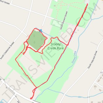
Stoney Creek Park Loop
- Distance: 2.0 mi
- Elevation gain: 19 m
- Maximum elevation: 33 m
- Elevation loss: 19 m
- Minimum elevation: 24 m
- Moving time: 39 m 44 s
- Moving speed: 3.1 mph
- Maximum speed: 7.5 mph
- Total time: 39 m 44 s
- Global speed: 3.1 mph
Interactive trail map
Trail profile
- Distance: 2.0 mi
- Elevation gain: 19 m
- Maximum elevation: 33 m
- Elevation loss: 19 m
- Minimum elevation: 24 m
- Moving time: 39 m 44 s
- Moving speed: 3.1 mph
- Maximum speed: 7.5 mph
- Total time: 39 m 44 s
- Global speed: 3.1 mph
About this trail
Name: Stoney Creek Park Loop trail, distance, elevation, map, profile, GPS track
Coordinates: 35.36783 -77.96793 35.37513 -77.96115