Thank you for supporting this site ❤️
Make a donation
Make a donation
Gear up for your next adventure:
As an Amazon Associate, this site earns from qualifying purchases at no extra cost to you.
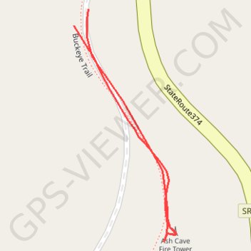
Ash Cave Fire Tower
A Hocking Hills Trail
- Distance: 0.2 mi
- Elevation gain: 8 m
- Maximum elevation: 329 m
- Elevation loss: 7 m
- Minimum elevation: 323 m
- Moving time: 5 m 2 s
- Moving speed: 2.6 mph
- Maximum speed: 3.6 mph
- Total time: 14 m 51 s
- Global speed: 0.9 mph
Interactive trail map
Thank you for supporting this site ❤️
Make a donation
Make a donation
Gear up for your next adventure:
As an Amazon Associate, this site earns from qualifying purchases at no extra cost to you.
Trail profile
- Distance: 0.2 mi
- Elevation gain: 8 m
- Maximum elevation: 329 m
- Elevation loss: 7 m
- Minimum elevation: 323 m
- Moving time: 5 m 2 s
- Moving speed: 2.6 mph
- Maximum speed: 3.6 mph
- Total time: 14 m 51 s
- Global speed: 0.9 mph
Thank you for supporting this site ❤️
Make a donation
Make a donation
Gear up for your next adventure:
As an Amazon Associate, this site earns from qualifying purchases at no extra cost to you.
About this trail
Name: Ash Cave Fire Tower trail, distance, elevation, map, profile, GPS track
Start: Buckeye Trail, Hocking County, Ohio, United States (39.40710 -82.53150)
End: Buckeye Trail, Hocking County, Ohio, United States (39.40720 -82.53139)
Coordinates: 39.40580 -82.53150 39.40720 -82.53070
Thank you for supporting this site ❤️
Make a donation
Make a donation
Gear up for your next adventure:
As an Amazon Associate, this site earns from qualifying purchases at no extra cost to you.