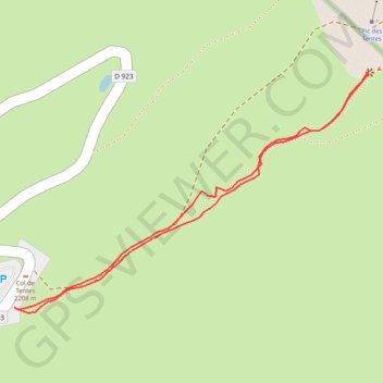
Pico Tentes desde el col de Tentes
- Distance: 0.8 mi
- Elevation gain: 100 m
- Maximum elevation: 2,309 m
- Elevation loss: 101 m
- Minimum elevation: 2,208 m
Interactive trail map
Trail profile
- Distance: 0.8 mi
- Elevation gain: 100 m
- Maximum elevation: 2,309 m
- Elevation loss: 101 m
- Minimum elevation: 2,208 m
About this trail
Name: Pico Tentes desde el col de Tentes trail, distance, elevation, map, profile, GPS track
Coordinates: 42.71331 -0.05081 42.71632 -0.04482
Other hiking, mountain biking, running and outdoor activity trails
Click on a trail to view its statistics, map and profile.
GR 10 - Traversée des Pyrénées
France > Occitania > Pyrénées-Orientales > Banyuls-sur-Mer
Distance: 543.6 mi • Elevation gain: 57,000 m • Maximum elevation: 2,599 m
Southern section — European Divide Trail
France > Auvergne-Rhône-Alpes > Drôme > Valence
Distance: 1,506.1 mi • Elevation gain: 42,375 m • Maximum elevation: 2,005 m
1 LUCENA - MONTPELLIER
Distance: 1,842.0 mi • Elevation gain: 29,500 m • Maximum elevation: 1,048 m