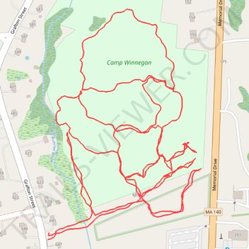
Camp Wunnegan trails
- Distance: 2.7 mi
- Elevation gain: 66 m
- Maximum elevation: 149 m
- Elevation loss: 66 m
- Minimum elevation: 126 m
- Moving time: 1 h 1 m
- Moving speed: 2.6 mph
- Maximum speed: 4.7 mph
- Total time: 1 h 4 m
- Global speed: 2.5 mph
Interactive trail map
Trail profile
- Distance: 2.7 mi
- Elevation gain: 66 m
- Maximum elevation: 149 m
- Elevation loss: 66 m
- Minimum elevation: 126 m
- Moving time: 1 h 1 m
- Moving speed: 2.6 mph
- Maximum speed: 4.7 mph
- Total time: 1 h 4 m
- Global speed: 2.5 mph
About this trail
Name: Camp Wunnegan trails trail, distance, elevation, map, profile, GPS track
Coordinates: 42.25387 -71.71611 42.25839 -71.71205
Other hiking, mountain biking, running and outdoor activity trails
Click on a trail to view its statistics, map and profile.
Loop in Eastern Mass involving various rail trails
United States > Massachusetts > Middlesex County > Newton
Distance: 126.6 mi • Elevation gain: 1,940 m • Maximum elevation: 194 m