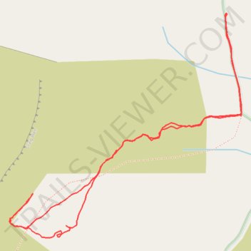
Walk up to Craig Wen and the manganese mine
- Distance: 1.8 mi
- Elevation gain: 189 m
- Maximum elevation: 417 m
- Elevation loss: 189 m
- Minimum elevation: 237 m
- Moving time: 1 h 14 m
- Moving speed: 1.5 mph
- Maximum speed: 3.4 mph
- Total time: 1 h 35 m
- Global speed: 1.2 mph
Interactive trail map
Trail profile
- Distance: 1.8 mi
- Elevation gain: 189 m
- Maximum elevation: 417 m
- Elevation loss: 189 m
- Minimum elevation: 237 m
- Moving time: 1 h 14 m
- Moving speed: 1.5 mph
- Maximum speed: 3.4 mph
- Total time: 1 h 35 m
- Global speed: 1.2 mph
About this trail
Name: Walk up to Craig Wen and the manganese mine trail, distance, elevation, map, profile, GPS track
Start: Bro Celyn, Clynnog, Gwynedd, Wales, LL54 5BT, United Kingdom (53.00452 -4.33041)
End: Bro Celyn, Clynnog, Gwynedd, Wales, LL54 5BT, United Kingdom (53.00449 -4.33041)
Coordinates: 52.99812 -4.34072 53.00454 -4.32971
Topography: Gwynedd topographic map, elevation, terrain