Thank you for supporting this site ❤️
Make a donation
Make a donation
Gear up for your next adventure:
As an Amazon Associate, this site earns from qualifying purchases at no extra cost to you.
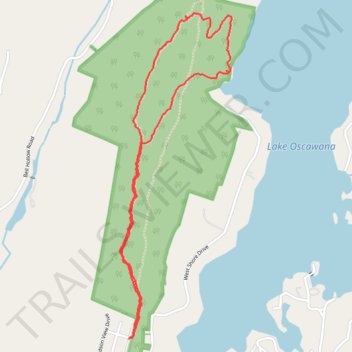
Oscawana Ridge and Lake Trail
- Distance: 2.9 mi
- Elevation gain: 139 m
- Maximum elevation: 248 m
- Elevation loss: 139 m
- Minimum elevation: 161 m
- Moving time: 1 h 14 m
- Moving speed: 2.4 mph
- Maximum speed: 25.7 mph
- Total time: 1 h 40 m
- Global speed: 1.8 mph
Interactive trail map
Thank you for supporting this site ❤️
Make a donation
Make a donation
Gear up for your next adventure:
As an Amazon Associate, this site earns from qualifying purchases at no extra cost to you.
Trail profile
- Distance: 2.9 mi
- Elevation gain: 139 m
- Maximum elevation: 248 m
- Elevation loss: 139 m
- Minimum elevation: 161 m
- Moving time: 1 h 14 m
- Moving speed: 2.4 mph
- Maximum speed: 25.7 mph
- Total time: 1 h 40 m
- Global speed: 1.8 mph
Thank you for supporting this site ❤️
Make a donation
Make a donation
Gear up for your next adventure:
As an Amazon Associate, this site earns from qualifying purchases at no extra cost to you.
About this trail
Name: Oscawana Ridge and Lake Trail trail, distance, elevation, map, profile, GPS track
Coordinates: 41.38635 -73.86011 41.40214 -73.85290
Thank you for supporting this site ❤️
Make a donation
Make a donation
Gear up for your next adventure:
As an Amazon Associate, this site earns from qualifying purchases at no extra cost to you.
Other hiking, mountain biking, running and outdoor activity trails
Click on a trail to view its statistics, map and profile.
Oscawana Lake and Ridge
United States > New York > Putnam County > Town of Putnam Valley > Sunnybrook
Distance: 3.6 mi • Elevation gain: 163 m • Maximum elevation: 262 m