Thank you for supporting this site ❤️
Make a donation
Make a donation
Gear up for your next adventure:
As an Amazon Associate, this site earns from qualifying purchases at no extra cost to you.
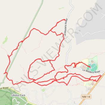
Campbell Scout Camp
- Distance: 13.4 mi
- Elevation gain: 463 m
- Maximum elevation: 2,227 m
- Elevation loss: 463 m
- Minimum elevation: 2,063 m
- Moving time: 3 h 9 m
- Moving speed: 4.2 mph
- Maximum speed: 20.4 mph
- Total time: 4 h 19 m
- Global speed: 3.1 mph
Interactive trail map
Thank you for supporting this site ❤️
Make a donation
Make a donation
Gear up for your next adventure:
As an Amazon Associate, this site earns from qualifying purchases at no extra cost to you.
Trail profile
- Distance: 13.4 mi
- Elevation gain: 463 m
- Maximum elevation: 2,227 m
- Elevation loss: 463 m
- Minimum elevation: 2,063 m
- Moving time: 3 h 9 m
- Moving speed: 4.2 mph
- Maximum speed: 20.4 mph
- Total time: 4 h 19 m
- Global speed: 3.1 mph
Thank you for supporting this site ❤️
Make a donation
Make a donation
Gear up for your next adventure:
As an Amazon Associate, this site earns from qualifying purchases at no extra cost to you.
About this trail
Name: Campbell Scout Camp trail, distance, elevation, map, profile, GPS track
Coordinates: 35.17050 -106.36999 35.18825 -106.33805
Thank you for supporting this site ❤️
Make a donation
Make a donation
Gear up for your next adventure:
As an Amazon Associate, this site earns from qualifying purchases at no extra cost to you.
Other hiking, mountain biking, running and outdoor activity trails
Click on a trail to view its statistics, map and profile.
Campbell Ranch
United States > New Mexico > Bernalillo County
Distance: 8.9 mi • Elevation gain: 314 m • Maximum elevation: 2,189 m