Make a donation
Gear up for your next adventure:
As an Amazon Associate, this site earns from qualifying purchases at no extra cost to you.
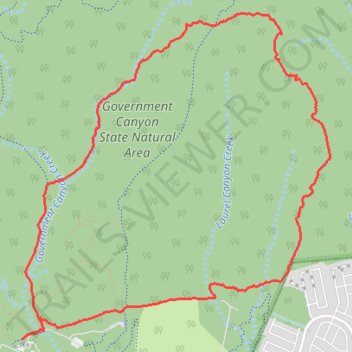
Loop hike via Recharge Trail, Far Reaches Trail and Wildcat Canyon Trail in Government Canyon State Natural Area
- Distance: 7.1 mi
- Elevation gain: 153 m
- Maximum elevation: 415 m
- Elevation loss: 151 m
- Minimum elevation: 310 m
- Moving time: 2 h 41 m
- Moving speed: 2.6 mph
- Maximum speed: 3.8 mph
- Total time: 3 h 6 m
- Global speed: 2.3 mph
Interactive trail map
Make a donation
Gear up for your next adventure:
As an Amazon Associate, this site earns from qualifying purchases at no extra cost to you.
Trail profile
- Distance: 7.1 mi
- Elevation gain: 153 m
- Maximum elevation: 415 m
- Elevation loss: 151 m
- Minimum elevation: 310 m
- Moving time: 2 h 41 m
- Moving speed: 2.6 mph
- Maximum speed: 3.8 mph
- Total time: 3 h 6 m
- Global speed: 2.3 mph
Make a donation
Gear up for your next adventure:
As an Amazon Associate, this site earns from qualifying purchases at no extra cost to you.
About this trail
Name: Loop hike via Recharge Trail, Far Reaches Trail and Wildcat Canyon Trail in Government Canyon State Natural Area trail, distance, elevation, map, profile, GPS track
Start: Interpretive Nature Trail, San Antonio, Bexar County, Texas, United States (29.54945 -98.76443)
End: Interpretive Nature Trail, San Antonio, Bexar County, Texas, United States (29.54927 -98.76475)
Coordinates: 29.54927 -98.76475 29.57740 -98.73419
Make a donation
Gear up for your next adventure:
As an Amazon Associate, this site earns from qualifying purchases at no extra cost to you.