Thank you for supporting this site ❤️
Make a donation
Make a donation
Gear up for your next adventure:
As an Amazon Associate, this site earns from qualifying purchases at no extra cost to you.
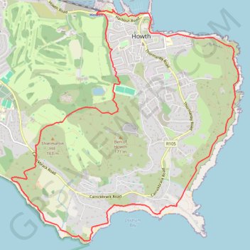
Howth Bog of Frogs Loop
- Distance: 7.4 mi
- Elevation gain: 428 m
- Maximum elevation: 124 m
- Elevation loss: 428 m
- Minimum elevation: -1 m
Interactive trail map
Thank you for supporting this site ❤️
Make a donation
Make a donation
Gear up for your next adventure:
As an Amazon Associate, this site earns from qualifying purchases at no extra cost to you.
Trail profile
- Distance: 7.4 mi
- Elevation gain: 428 m
- Maximum elevation: 124 m
- Elevation loss: 428 m
- Minimum elevation: -1 m
Thank you for supporting this site ❤️
Make a donation
Make a donation
Gear up for your next adventure:
As an Amazon Associate, this site earns from qualifying purchases at no extra cost to you.
About this trail
Name: Howth Bog of Frogs Loop trail, distance, elevation, map, profile, GPS track
Coordinates: 53.36068 -6.09189 53.38914 -6.04501
Thank you for supporting this site ❤️
Make a donation
Make a donation
Gear up for your next adventure:
As an Amazon Associate, this site earns from qualifying purchases at no extra cost to you.
Other hiking, mountain biking, running and outdoor activity trails
Click on a trail to view its statistics, map and profile.