Thank you for supporting this site ❤️
Make a donation
Make a donation
Gear up for your next adventure:
As an Amazon Associate, this site earns from qualifying purchases at no extra cost to you.
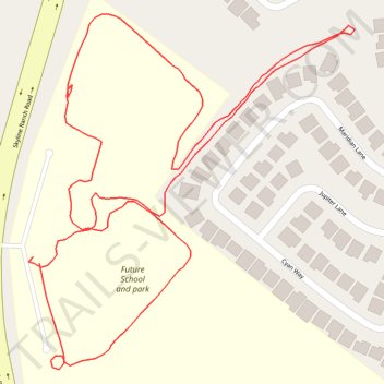
Skyline Ranch Park Loop Walk
- Distance: 1.0 mi
- Elevation gain: 71 m
- Maximum elevation: 585 m
- Elevation loss: 72 m
- Minimum elevation: 532 m
- Moving time: 24 m 4 s
- Moving speed: 2.4 mph
- Maximum speed: 4.3 mph
- Total time: 27 m 11 s
- Global speed: 2.1 mph
Interactive trail map
Thank you for supporting this site ❤️
Make a donation
Make a donation
Gear up for your next adventure:
As an Amazon Associate, this site earns from qualifying purchases at no extra cost to you.
Trail profile
- Distance: 1.0 mi
- Elevation gain: 71 m
- Maximum elevation: 585 m
- Elevation loss: 72 m
- Minimum elevation: 532 m
- Moving time: 24 m 4 s
- Moving speed: 2.4 mph
- Maximum speed: 4.3 mph
- Total time: 27 m 11 s
- Global speed: 2.1 mph
Thank you for supporting this site ❤️
Make a donation
Make a donation
Gear up for your next adventure:
As an Amazon Associate, this site earns from qualifying purchases at no extra cost to you.
About this trail
Name: Skyline Ranch Park Loop Walk trail, distance, elevation, map, profile, GPS track
Coordinates: 34.43507 -118.45791 34.43794 -118.45472
Thank you for supporting this site ❤️
Make a donation
Make a donation
Gear up for your next adventure:
As an Amazon Associate, this site earns from qualifying purchases at no extra cost to you.