Thank you for supporting this site ❤️
Make a donation
Make a donation
Gear up for your next adventure:
As an Amazon Associate, this site earns from qualifying purchases at no extra cost to you.
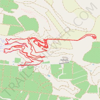
Muratie Ride
- Distance: 9.0 mi
- Elevation gain: 492 m
- Maximum elevation: 460 m
- Elevation loss: 483 m
- Minimum elevation: 265 m
- Moving time: 1 h 25 m
- Moving speed: 6.3 mph
- Maximum speed: 37.8 mph
- Total time: 1 h 49 m
- Global speed: 4.9 mph
Interactive trail map
Thank you for supporting this site ❤️
Make a donation
Make a donation
Gear up for your next adventure:
As an Amazon Associate, this site earns from qualifying purchases at no extra cost to you.
Trail profile
- Distance: 9.0 mi
- Elevation gain: 492 m
- Maximum elevation: 460 m
- Elevation loss: 483 m
- Minimum elevation: 265 m
- Moving time: 1 h 25 m
- Moving speed: 6.3 mph
- Maximum speed: 37.8 mph
- Total time: 1 h 49 m
- Global speed: 4.9 mph
Thank you for supporting this site ❤️
Make a donation
Make a donation
Gear up for your next adventure:
As an Amazon Associate, this site earns from qualifying purchases at no extra cost to you.
About this trail
Name: Muratie Ride trail, distance, elevation, map, profile, GPS track
Coordinates: -33.87052 18.87219 -33.86460 18.89310
Thank you for supporting this site ❤️
Make a donation
Make a donation
Gear up for your next adventure:
As an Amazon Associate, this site earns from qualifying purchases at no extra cost to you.