West Redstone Loop Hike
- Distance: 4.8 mi
- Elevation gain: 178 m
- Maximum elevation: 745 m
- Elevation loss: 178 m
- Minimum elevation: 635 m
- Moving time: 1 h 58 m
- Moving speed: 2.4 mph
- Maximum speed: 4.0 mph
- Total time: 2 h 3 m
- Global speed: 2.3 mph
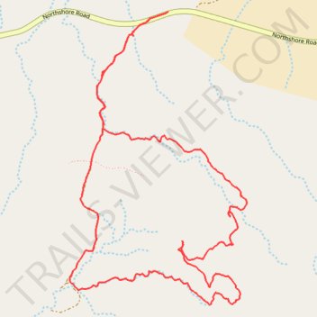
Interactive trail map
Trail profile
- Distance: 4.8 mi
- Elevation gain: 178 m
- Maximum elevation: 745 m
- Elevation loss: 178 m
- Minimum elevation: 635 m
- Moving time: 1 h 58 m
- Moving speed: 2.4 mph
- Maximum speed: 4.0 mph
- Total time: 2 h 3 m
- Global speed: 2.3 mph
About this trail
Name: West Redstone Loop Hike trail, distance, elevation, map, profile, GPS track
Start: Northshore Road, Clark County, Nevada, United States (36.24337 -114.53803)
End: Northshore Road, Clark County, Nevada, United States (36.24339 -114.53795)
Coordinates: 36.22659 -114.54495 36.24339 -114.53237