Alum Cliffs Track
- Distance: 3.6 mi
- Elevation gain: 242 m
- Maximum elevation: 96 m
- Elevation loss: 256 m
- Minimum elevation: 0 m
- Moving time: 1 h 26 m
- Moving speed: 2.5 mph
- Maximum speed: 7.0 mph
- Total time: 1 h 30 m
- Global speed: 2.4 mph
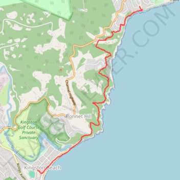
Interactive trail map
Trail profile
- Distance: 3.6 mi
- Elevation gain: 242 m
- Maximum elevation: 96 m
- Elevation loss: 256 m
- Minimum elevation: 0 m
- Moving time: 1 h 26 m
- Moving speed: 2.5 mph
- Maximum speed: 7.0 mph
- Total time: 1 h 30 m
- Global speed: 2.4 mph
About this trail
Name: Alum Cliffs Track trail, distance, elevation, map, profile, GPS track
Start: Hinsby Road, Taroona, Hobart, Kingborough, Tasmania, 7053, Australia (-42.95264 147.34731)
End: Beach Road, Kingston Beach, Hobart, Kingborough, Tasmania, 7050, Australia (-42.98114 147.32306)
Coordinates: -42.98171 147.32306 -42.95264 147.34814