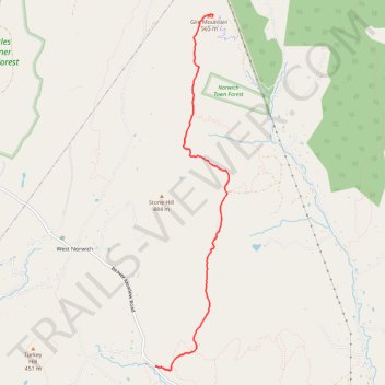
Gile Mountain via Blue Ribbon Trail
- Distance: 3.5 mi
- Elevation gain: 272 m
- Maximum elevation: 561 m
- Elevation loss: 42 m
- Minimum elevation: 327 m
- Moving time: 56 m 13 s
- Moving speed: 3.7 mph
- Maximum speed: 12.7 mph
- Total time: 57 m 15 s
- Global speed: 3.7 mph
Interactive trail map
Trail profile
- Distance: 3.5 mi
- Elevation gain: 272 m
- Maximum elevation: 561 m
- Elevation loss: 42 m
- Minimum elevation: 327 m
- Moving time: 56 m 13 s
- Moving speed: 3.7 mph
- Maximum speed: 12.7 mph
- Total time: 57 m 15 s
- Global speed: 3.7 mph
About this trail
Name: Gile Mountain via Blue Ribbon Trail trail, distance, elevation, map, profile, GPS track
Start: Blue Ribbon Trail, Norwich, Windsor County, Vermont, 05055, United States (43.75084 -72.36007)
End: Firetower Trail, Norwich, Windsor County, Vermont, United States (43.78895 -72.35156)
Coordinates: 43.75039 -72.36007 43.78931 -72.34893
Other hiking, mountain biking, running and outdoor activity trails
Click on a trail to view its statistics, map and profile.