Thank you for supporting this site ❤️
Make a donation
Make a donation
Gear up for your next adventure:
As an Amazon Associate, this site earns from qualifying purchases at no extra cost to you.
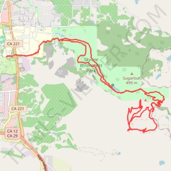
Great New trails at Napa Skyline
- Distance: 19.1 mi
- Elevation gain: 1,068 m
- Maximum elevation: 451 m
- Elevation loss: 1,068 m
- Minimum elevation: 5 m
Interactive trail map
Thank you for supporting this site ❤️
Make a donation
Make a donation
Gear up for your next adventure:
As an Amazon Associate, this site earns from qualifying purchases at no extra cost to you.
Trail profile
- Distance: 19.1 mi
- Elevation gain: 1,068 m
- Maximum elevation: 451 m
- Elevation loss: 1,068 m
- Minimum elevation: 5 m
Thank you for supporting this site ❤️
Make a donation
Make a donation
Gear up for your next adventure:
As an Amazon Associate, this site earns from qualifying purchases at no extra cost to you.
About this trail
Name: Great New trails at Napa Skyline trail, distance, elevation, map, profile, GPS track
Coordinates: 38.24334 -122.27577 38.27572 -122.20662
Thank you for supporting this site ❤️
Make a donation
Make a donation
Gear up for your next adventure:
As an Amazon Associate, this site earns from qualifying purchases at no extra cost to you.