Waihe'e Ridge and Lanilili (Maui Island)
Hike to Waihe'e Ridge and Lanilili via Waihe'e Ridge Trail on Maui Island. #Hiking #Mountain #Volcano #Nature #Forest #Island #Hawaii #Sea #Pacific #Ocean
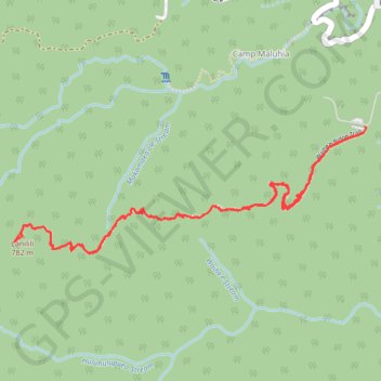
- Distance: 4.3 mi
- Elevation gain: 464 m
- Maximum elevation: 766 m
- Elevation loss: 469 m
- Minimum elevation: 326 m
- Moving time: 2 h 35 s
- Moving speed: 2.1 mph
- Maximum speed: 25.9 mph
- Total time: 2 h 58 m
- Global speed: 1.5 mph
Interactive trail map
Trail profile
- Distance: 4.3 mi
- Elevation gain: 464 m
- Maximum elevation: 766 m
- Elevation loss: 469 m
- Minimum elevation: 326 m
- Moving time: 2 h 35 s
- Moving speed: 2.1 mph
- Maximum speed: 25.9 mph
- Total time: 2 h 58 m
- Global speed: 1.5 mph
About this trail
Name: Waihe'e Ridge and Lanilili (Maui Island) trail, distance, elevation, map, profile, GPS track
Start: Waiheʻe Ridge Trail, Camp Maluhia, Maui County, Hawaii, United States (20.95246 -156.53202)
End: Waiheʻe Ridge Trail, Camp Maluhia, Maui County, Hawaii, United States (20.95276 -156.53190)
Coordinates: 20.94613 -156.55166 20.95276 -156.53183