Make a donation
Gear up for your next adventure:
As an Amazon Associate, this site earns from qualifying purchases at no extra cost to you.
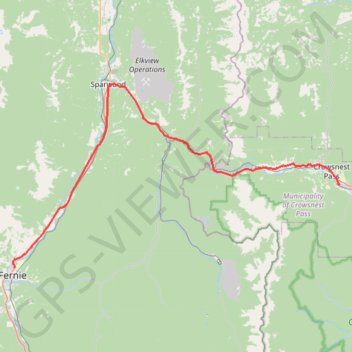
Fernie - Blairmore
Interactive trail map
Make a donation
Gear up for your next adventure:
As an Amazon Associate, this site earns from qualifying purchases at no extra cost to you.
Trail profile
- Distance: 42.4 mi
- Elevation gain: 682 m
- Maximum elevation: 1,393 m
- Elevation loss: 378 m
- Minimum elevation: 1,000 m
Make a donation
Gear up for your next adventure:
As an Amazon Associate, this site earns from qualifying purchases at no extra cost to you.
About this trail
Name: Fernie - Blairmore trail, distance, elevation, map, profile, GPS track
Coordinates: 49.51294 -115.06157 49.73331 -114.45937
Make a donation
Gear up for your next adventure:
As an Amazon Associate, this site earns from qualifying purchases at no extra cost to you.
Other hiking, mountain biking, running and outdoor activity trails
Click on a trail to view its statistics, map and profile.
Blairmore - Pincher Creek
Canada > Alberta > Crowsnest Pass
#Bike #Blairmore #PincherCreek
Distance: 29.4 mi • Elevation gain: 259 m • Maximum elevation: 1,304 m
Fairy Creek Waterfall Trail
Canada > British Columbia > Regional District of East Kootenay > Fernie
#Hiking #MTB #Snowshoeing #Forest #Falls
Distance: 2.8 mi • Elevation gain: 148 m • Maximum elevation: 1,083 m