Thank you for supporting this site ❤️
Make a donation
Make a donation
Gear up for your next adventure:
As an Amazon Associate, this site earns from qualifying purchases at no extra cost to you.
Orillia - Lindsay
Interactive trail map
Thank you for supporting this site ❤️
Make a donation
Make a donation
Gear up for your next adventure:
As an Amazon Associate, this site earns from qualifying purchases at no extra cost to you.
Trail profile
- Distance: 51.7 mi
- Elevation gain: 375 m
- Maximum elevation: 301 m
- Elevation loss: 345 m
- Minimum elevation: 221 m
Thank you for supporting this site ❤️
Make a donation
Make a donation
Gear up for your next adventure:
As an Amazon Associate, this site earns from qualifying purchases at no extra cost to you.
About this trail
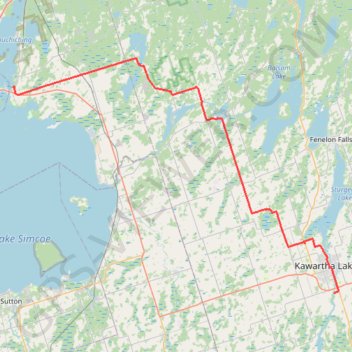
Name: Orillia - Lindsay trail, distance, elevation, map, profile, GPS track
Coordinates: 44.32067 -79.36066 44.65060 -78.72081
Thank you for supporting this site ❤️
Make a donation
Make a donation
Gear up for your next adventure:
As an Amazon Associate, this site earns from qualifying purchases at no extra cost to you.
Other hiking, mountain biking, running and outdoor activity trails
Click on a trail to view its statistics, map and profile.
Wasaga Beach - Orillia
Canada > Ontario > Simcoe County > Wasaga Beach
Distance: 50.5 mi • Elevation gain: 450 m • Maximum elevation: 343 m