נחל יצהר - OG
Olive oil with OG
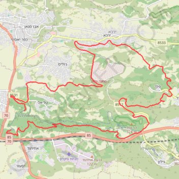
- Distance: 20.6 mi
- Elevation gain: 911 m
- Maximum elevation: 507 m
- Elevation loss: 967 m
- Minimum elevation: 43 m
Interactive trail map
Trail profile
- Distance: 20.6 mi
- Elevation gain: 911 m
- Maximum elevation: 507 m
- Elevation loss: 967 m
- Minimum elevation: 43 m
About this trail
Name: נחל יצהר - OG trail, distance, elevation, map, profile, GPS track
Start: 8531, Tal El, Misgav Regional Council, Acre Subdistrict, North District, Israel (32.92387 35.16817)
Coordinates: 32.91231 35.15955 32.95284 35.24080