Thank you for supporting this site ❤️
Make a donation
Make a donation
Gear up for your next adventure:
As an Amazon Associate, this site earns from qualifying purchases at no extra cost to you.
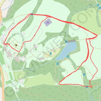
Sirromet Winery
- Distance: 5.7 mi
- Elevation gain: 136 m
- Maximum elevation: 58 m
- Elevation loss: 117 m
- Minimum elevation: 27 m
- Moving time: 50 m 51 s
- Moving speed: 6.7 mph
- Maximum speed: 11.9 mph
- Total time: 1 h 8 m
- Global speed: 5.0 mph
Interactive trail map
Thank you for supporting this site ❤️
Make a donation
Make a donation
Gear up for your next adventure:
As an Amazon Associate, this site earns from qualifying purchases at no extra cost to you.
Trail profile
- Distance: 5.7 mi
- Elevation gain: 136 m
- Maximum elevation: 58 m
- Elevation loss: 117 m
- Minimum elevation: 27 m
- Moving time: 50 m 51 s
- Moving speed: 6.7 mph
- Maximum speed: 11.9 mph
- Total time: 1 h 8 m
- Global speed: 5.0 mph
Thank you for supporting this site ❤️
Make a donation
Make a donation
Gear up for your next adventure:
As an Amazon Associate, this site earns from qualifying purchases at no extra cost to you.
About this trail
Name: Sirromet Winery trail, distance, elevation, map, profile, GPS track
Coordinates: -27.59797 153.22914 -27.58958 153.24116
Thank you for supporting this site ❤️
Make a donation
Make a donation
Gear up for your next adventure:
As an Amazon Associate, this site earns from qualifying purchases at no extra cost to you.