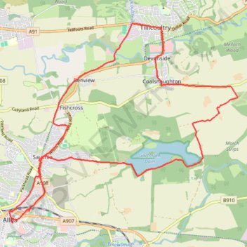
Bike ride around Coalsnaughton via Tillicoultry, Alloa and Gartmorn Dam
- Distance: 11.3 mi
- Elevation gain: 171 m
- Maximum elevation: 102 m
- Elevation loss: 171 m
- Minimum elevation: 13 m
- Moving time: 1 h 12 m
- Moving speed: 9.4 mph
- Maximum speed: 27.3 mph
- Total time: 2 h 26 m
- Global speed: 4.6 mph
Interactive trail map
Trail profile
- Distance: 11.3 mi
- Elevation gain: 171 m
- Maximum elevation: 102 m
- Elevation loss: 171 m
- Minimum elevation: 13 m
- Moving time: 1 h 12 m
- Moving speed: 9.4 mph
- Maximum speed: 27.3 mph
- Total time: 2 h 26 m
- Global speed: 4.6 mph
About this trail
Name: Bike ride around Coalsnaughton via Tillicoultry, Alloa and Gartmorn Dam trail, distance, elevation, map, profile, GPS track
Coordinates: 56.11499 -3.79253 56.15386 -3.71271
Topography: Clackmannanshire topographic map, elevation, terrain