Thank you for supporting this site ❤️
Make a donation
Make a donation
Gear up for your next adventure:
As an Amazon Associate, this site earns from qualifying purchases at no extra cost to you.
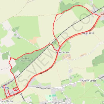
Ropley roads & rails
- Distance: 6.6 mi
- Elevation gain: 174 m
- Maximum elevation: 185 m
- Elevation loss: 160 m
- Minimum elevation: 94 m
- Moving time: 1 h 1 m
- Moving speed: 6.4 mph
- Maximum speed: 11.0 mph
- Total time: 1 h 2 m
- Global speed: 6.3 mph
Interactive trail map
Thank you for supporting this site ❤️
Make a donation
Make a donation
Gear up for your next adventure:
As an Amazon Associate, this site earns from qualifying purchases at no extra cost to you.
Trail profile
- Distance: 6.6 mi
- Elevation gain: 174 m
- Maximum elevation: 185 m
- Elevation loss: 160 m
- Minimum elevation: 94 m
- Moving time: 1 h 1 m
- Moving speed: 6.4 mph
- Maximum speed: 11.0 mph
- Total time: 1 h 2 m
- Global speed: 6.3 mph
Thank you for supporting this site ❤️
Make a donation
Make a donation
Gear up for your next adventure:
As an Amazon Associate, this site earns from qualifying purchases at no extra cost to you.
About this trail
Name: Ropley roads & rails trail, distance, elevation, map, profile, GPS track
Coordinates: 51.08411 -1.10312 51.10702 -1.06528
Topography: East Hampshire topographic map, elevation, terrain
Thank you for supporting this site ❤️
Make a donation
Make a donation
Gear up for your next adventure:
As an Amazon Associate, this site earns from qualifying purchases at no extra cost to you.