Thank you for supporting this site ❤️
Make a donation
Make a donation
Gear up for your next adventure:
As an Amazon Associate, this site earns from qualifying purchases at no extra cost to you.
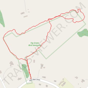
Davidson sanctuary / Fay Grant Bird Sanctuary
- Distance: 1.2 mi
- Elevation gain: 45 m
- Maximum elevation: 218 m
- Elevation loss: 46 m
- Minimum elevation: 177 m
- Moving time: 28 m 44 s
- Moving speed: 2.6 mph
- Maximum speed: 5.1 mph
- Total time: 30 m 10 s
- Global speed: 2.4 mph
Interactive trail map
Thank you for supporting this site ❤️
Make a donation
Make a donation
Gear up for your next adventure:
As an Amazon Associate, this site earns from qualifying purchases at no extra cost to you.
Trail profile
- Distance: 1.2 mi
- Elevation gain: 45 m
- Maximum elevation: 218 m
- Elevation loss: 46 m
- Minimum elevation: 177 m
- Moving time: 28 m 44 s
- Moving speed: 2.6 mph
- Maximum speed: 5.1 mph
- Total time: 30 m 10 s
- Global speed: 2.4 mph
Thank you for supporting this site ❤️
Make a donation
Make a donation
Gear up for your next adventure:
As an Amazon Associate, this site earns from qualifying purchases at no extra cost to you.
About this trail
Name: Davidson sanctuary / Fay Grant Bird Sanctuary trail, distance, elevation, map, profile, GPS track
Coordinates: 42.17733 -71.81257 42.18171 -71.80568
Thank you for supporting this site ❤️
Make a donation
Make a donation
Gear up for your next adventure:
As an Amazon Associate, this site earns from qualifying purchases at no extra cost to you.
Other hiking, mountain biking, running and outdoor activity trails
Click on a trail to view its statistics, map and profile.
Loop in Eastern Mass involving various rail trails
United States > Massachusetts > Middlesex County > Newton
Distance: 126.6 mi • Elevation gain: 1,940 m • Maximum elevation: 194 m