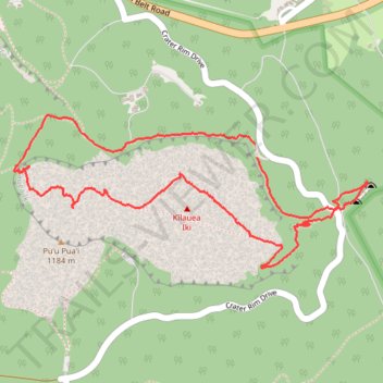
Kilauea Iki Loop Trail
- Distance: 3.9 mi
- Elevation gain: 205 m
- Maximum elevation: 1,204 m
- Elevation loss: 215 m
- Minimum elevation: 1,063 m
- Moving time: 1 h 30 m
- Moving speed: 2.6 mph
- Maximum speed: 6.6 mph
- Total time: 1 h 50 m
- Global speed: 2.1 mph
Interactive trail map
Trail profile
- Distance: 3.9 mi
- Elevation gain: 205 m
- Maximum elevation: 1,204 m
- Elevation loss: 215 m
- Minimum elevation: 1,063 m
- Moving time: 1 h 30 m
- Moving speed: 2.6 mph
- Maximum speed: 6.6 mph
- Total time: 1 h 50 m
- Global speed: 2.1 mph
About this trail
Name: Kilauea Iki Loop Trail trail, distance, elevation, map, profile, GPS track
Start: Crater Rim Trail, Hawaiʻi County, Hawaii, 96718, United States (19.41692 -155.24301)
End: Crater Rim Trail, Hawaiʻi County, Hawaii, 96718, United States (19.41629 -155.24291)
Coordinates: 19.41079 -155.25571 19.41840 -155.23703