Thank you for supporting this site ❤️
Make a donation
Make a donation
Gear up for your next adventure:
As an Amazon Associate, this site earns from qualifying purchases at no extra cost to you.
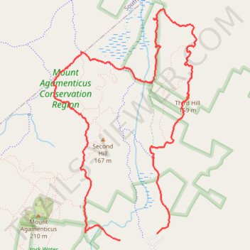
Old Mountain Loop via Porcupine Trail, Notch Trail, Great Marsh Trail and Third Hill Trail
Mount Agamenticus Conservation Region
- Distance: 5.8 mi
- Elevation gain: 167 m
- Maximum elevation: 153 m
- Elevation loss: 175 m
- Minimum elevation: 62 m
- Moving time: 2 h 11 m
- Moving speed: 2.7 mph
- Maximum speed: 7.0 mph
- Total time: 2 h 19 m
- Global speed: 2.5 mph
Interactive trail map
Thank you for supporting this site ❤️
Make a donation
Make a donation
Gear up for your next adventure:
As an Amazon Associate, this site earns from qualifying purchases at no extra cost to you.
Trail profile
- Distance: 5.8 mi
- Elevation gain: 167 m
- Maximum elevation: 153 m
- Elevation loss: 175 m
- Minimum elevation: 62 m
- Moving time: 2 h 11 m
- Moving speed: 2.7 mph
- Maximum speed: 7.0 mph
- Total time: 2 h 19 m
- Global speed: 2.5 mph
Thank you for supporting this site ❤️
Make a donation
Make a donation
Gear up for your next adventure:
As an Amazon Associate, this site earns from qualifying purchases at no extra cost to you.
About this trail
Name: Old Mountain Loop via Porcupine Trail, Notch Trail, Great Marsh Trail and Third Hill Trail trail, distance, elevation, map, profile, GPS track
Coordinates: 43.22077 -70.69008 43.24488 -70.66952
Thank you for supporting this site ❤️
Make a donation
Make a donation
Gear up for your next adventure:
As an Amazon Associate, this site earns from qualifying purchases at no extra cost to you.