Port William to North Arm
- Distance: 7.8 mi
- Elevation gain: 425 m
- Maximum elevation: 181 m
- Elevation loss: 400 m
- Minimum elevation: 0 m
- Moving time: 4 h 8 m
- Moving speed: 1.9 mph
- Maximum speed: 3.4 mph
- Total time: 5 h 5 m
- Global speed: 1.5 mph
Interactive trail map
Trail profile
- Distance: 7.8 mi
- Elevation gain: 425 m
- Maximum elevation: 181 m
- Elevation loss: 400 m
- Minimum elevation: 0 m
- Moving time: 4 h 8 m
- Moving speed: 1.9 mph
- Maximum speed: 3.4 mph
- Total time: 5 h 5 m
- Global speed: 1.5 mph
About this trail
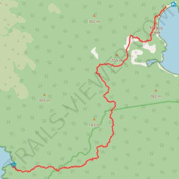
Name: Port William to North Arm trail, distance, elevation, map, profile, GPS track
Coordinates: -46.88525 168.01803 -46.83664 168.08407
Other hiking, mountain biking, running and outdoor activity trails
Click on a trail to view its statistics, map and profile.
Lee Bay to Port William
New Zealand > Southland > Southland District > Stewart Island / Rakiura Community
Distance: 5.1 mi • Elevation gain: 332 m • Maximum elevation: 119 m
North Arm to Oban
New Zealand > Southland > Southland District > Stewart Island / Rakiura Community
Distance: 7.8 mi • Elevation gain: 319 m • Maximum elevation: 101 m