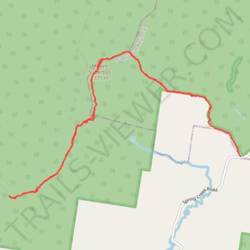
Mount Superbus and Lincoln Ridge Track
- Distance: 8.6 mi
- Elevation gain: 753 m
- Maximum elevation: 1,348 m
- Elevation loss: 823 m
- Minimum elevation: 777 m
- Moving time: 7 h 29 s
- Moving speed: 1.2 mph
- Maximum speed: 3.0 mph
- Total time: 10 h 26 m
- Global speed: 0.8 mph
Interactive trail map
Trail profile
- Distance: 8.6 mi
- Elevation gain: 753 m
- Maximum elevation: 1,348 m
- Elevation loss: 823 m
- Minimum elevation: 777 m
- Moving time: 7 h 29 s
- Moving speed: 1.2 mph
- Maximum speed: 3.0 mph
- Total time: 10 h 26 m
- Global speed: 0.8 mph
About this trail
Name: Mount Superbus and Lincoln Ridge Track trail, distance, elevation, map, profile, GPS track
Start: Mt Superbus Trail, Carneys Creek, Scenic Rim Regional, Queensland, Australia (-28.22565 152.47905)
End: The Head Road, The Head, Southern Downs Regional, Queensland, Australia (-28.23280 152.48435)
Coordinates: -28.23913 152.44496 -28.21706 152.48435